Mount Baker (July 3, 2013)
As the snow melted sufficiently for the snow cats and plows to cut through, one of the most scenic spots in the North cascades, Artist Point was opened recently and afforded us its dramatic 360 degree view. At an elevation of 5,100 feet, Artist Point is situated between Mt. Baker, the live volcano and its neighbor, Mt. Shuksan, a non-volcanic, faulted behemoth. This area is rich in geologic history and features and as the authors of Hiking Washington’s Geology state:
“Standing in the parking lot at Artists Point, you can see as much geology in the 360 degree sweep as in almost any other location in the world.”
This 360 degree sweep from Artist Point is amateurishly illustrated in this iphone video. Standing in the parking lot at Artist Point, the sweep begins at Mt. Shuksan, moves to just seeing the top of Baker, then to Table Mountain, then to the north toward Canada, and finally back to Shuksan:
I was unable to imbed the video but here is URL on You tube) http://youtu.be/efE9hH-nlTI I will try to embed the video in a comment.
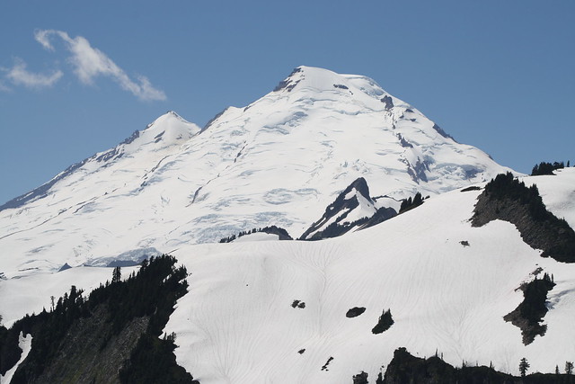
Mt. Baker is an isolated stratovolcano (built up of numerous layers of lava) in the northern Cascade range of Washington State. It lies about 30 miles east of Bellingham and Bellingham Bay and about 17 miles south of the Canadian Border. It is the northern most of the five Washington State Cascade volcanoes. (Other state volcanoes include Mts. St. Helens, Adams, Rainier, and Glacier Peak.) Most of Baker’s volcanic cone is covered by steep glaciers giving rise to its Indian name: Komo Kulshan, meaning “White Steep Mountain”. More recently, Captain George Vancouver named it Mt. Baker in honor if his 3rd Lt., Joseph Baker. I prefer Komo Kulshan.
Mt. Baker dominates the view from much of the northwest portion of the state from Seattle to the lower mainland of British Columbia as it rises 10,781 feet (3285 m), just 30 miles inland from the Salish Sea. (Mt. Baker is literally in my back yard as my house is in the lower right hand corner of the photo below.)

Mt. Baker seen from Bellingham Bay
Mt. Baker is the youngest volcano in the Cascade chain, having formed during and since the last ice age, which ended about 15,000 years ago. The current cone was constructed only over the past 7,000 years. Earlier lava flow accumulations were largely eroded by glaciers and the Cordilleran Ice sheet that extended down from Canada, carved out Puget Sound, and covered the northern one third of the state during the Pleistocene ice age.

Like some other Cascade volcanoes such as Mt. Rainier and Hood, Baker is built of successive lava flows of andesite, rather than basaltic lava that form other cascade volcanoes as well as much of the terrain of the eastern part of the state. Outcrops of columnar andesite are evident in various sites around the area. In one such outcrop the columns are reportedly horizontal, suggesting that the lava ran down a valley where it cooled into the horizontal columns. In the outcrop shown below, most columns are vertical but some show a slant, probably a result of local environmental stresses.
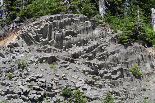
Columnar Andesite
Based on Baker’s history, it is said to be overdue for an eruption. However, in geological terms ‘overdue’ could mean another 500-1,000 years. Mt. Baker has been very active over the last 10,000 years and has erupted approximately 13 times in recorded history. Its last full eruption was in 1880. More recently however, it has periodically had steam and lahar episodes, the last being 1975-1976 when the internal temperature (heat flow) increased some tenfold.
Currently, plumes of steam rise in the cold winter air from Sherman Crater, giving an ominous appearance, although we are told there is no cause for immediate alarm. However, in the 1975-76 heat up, in the interest of public safety, the Forest Service closed the north shore and campgrounds of Baker Lake which lies about 9 miles south east of the mountain as this had been the site and direction of some of the most recent lahar flows.
The US Geological Survey and University of Washington Pacific Northwest Seismographic Network continuously monitor seismic activity while the USGS monitors gas emissions from Sherman Crater.
In contrast to our local volcano, lying only about 11 miles to the east north east is Mt. Shuksan at 9,131feet (2,783 m) and constructed from quite different geologic processes. Its structure is that of a glaciated massif (a large collection of crust) composed of Shuksan greenschist, a metamorphosed oceanic basalt from some 120 million years ago that was more recently thrust upward in a collision with the North American tectonic plate. Fortunately, Mt. Shuksan retained its native name from the indigenous Lummi Indians meaning “high peak.”
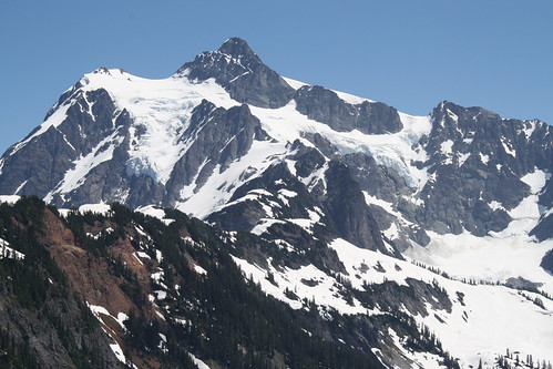
Mt. Shuksan
The area around these two mountains affords a wealth of year round recreational activities. Mt. Baker Ski Area is a great favorite, often accumulating over 200 inches of snow a year. Downhill and cross country skiing, snowboarding, and snow shoeing, are all readily available.
The Forest Service maintains numerous hiking trails from which one can view the flora, fauna, and geology, along with the magnificent alpine views. A number of hiking and climbing clubs are available to lead climbers on the several routes up both mountains. There are a number of camp grounds near by along the Nooksack River that collects much of the snow melt run off from the glaciers.
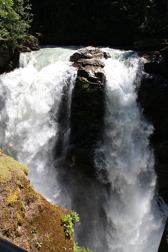
Nooksack Falls
Below is a photo of Table Mountain with one of the six chain Lakes at its foot. Six and one half miles of well maintained trails connect the six lakes that surround the mountain.
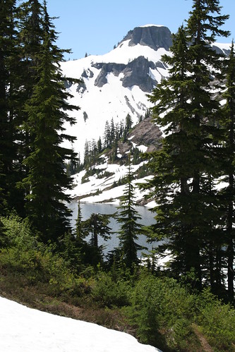
Table Mountain
29 comments