Motley Moose – Archive

Since 2008 – Progress Through Politics

Bellingham

Rhododendron Time

2014-05-19 Garden St.

Spring time is Rhododendron time around the world. These prolific bloomers are native to Asia, North America, Australia, and Europe. They are members of the Genus Rhododendron  and the Family of Ericaceae (Heaths). The name is derived from ancient Greek (rhódon “rose” or “red“) and déndron “tree”). There are some 800 to 1,000 species and 28,000 cultivars listed by the Royal Horticultural Society. Azaleas are a subgenera of Rhododendron.

Death and renewal: Whatcom Creek Habitat Restoration


                    Upper Falls, Whatcom Creek, Whatcom Falls Park, Bellingham, WA

Whatcom Creek is the third salmon spawning stream that runs through Bellingham. I promised in my last diary that it would be the last. However, I took so many photos and there was too much stuff. So, here I will describe the creek and its history. The next one will focus on both the primeval timelessness of the creek itself and illustrate how its two fish hatcheries are working to keep this marvelous place for future generations.  

Padden Creek Salmon Habitat Restoration Project


                                          Padden Creek at Fairhaven Park

Among the icons associated with the Pacific Northwest are evergreen trees, rain, streams, and salmon. These PNW icons have existed in symbiotic relations with one another for probably millions of years. A change in one can affect the others. But apparently this fact was unknown or at least unappreciated by the early American settlers of this region. They over-logged the trees which allowed the abundant rain to wash mud and whole hillsides into the streams which became uninhabitable for the salmon that had used these streams for eons to maintain their life cycles. They also dammed up spawning rivers to provide electricity to run their sawmills and salmon canneries. The irony is that they destroyed the very things that made them wealthy.  

Fossils and Pseudofossils in the The Chuckanut Formation: Part 2, fauna

This is the second of my two-part diary of the fossils from the Chuckanut Formation (C/F), located near Bellingham in Northwestern Washington State. As noted in part 1, (flora), this formation developed during the  Eocene Epoch, some 50 million years ago (ma). This area was a subtropical fluvial plain on to which sediments were deposited and ultimately hardened into sandstone, shale, and siltstone that captured specimens of both flora and fauna of that time. (No new pseudofossils in this part.)


                         Racehorse Creek land slide and fossil beds

A Volcano in my Backyard

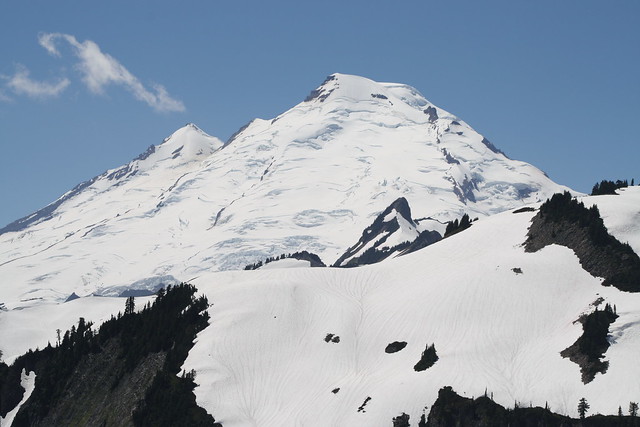
                                        Mount Baker (July 3, 2013)

As the snow melted sufficiently for the snow cats and plows to cut through, one of the most scenic spots in the North cascades, Artist Point was opened recently and afforded us its  dramatic 360 degree view. At an elevation of 5,100 feet, Artist Point is situated between Mt. Baker, the live volcano and its neighbor, Mt. Shuksan, a non-volcanic, faulted behemoth. This area is rich in geologic history and features and as the authors of Hiking Washington’s Geology state:

“Standing in the parking lot at Artists Point, you can see as much geology in the 360 degree sweep as in almost any other location in the world.”

This 360 degree sweep from Artist Point is amateurishly illustrated in this iphone video. Standing in the parking lot at Artist Point, the sweep begins at Mt. Shuksan, moves to just seeing the top of Baker, then to Table Mountain, then to the north toward Canada, and finally back to Shuksan:

I was unable to imbed the video but here is URL on You tube)  http://youtu.be/efE9hH-nlTI  I will try to embed the video in a comment.

An Introduction from Ronk – My Pacific Northwest home.

Hello Motley Moose,

 This is my introductory diary on the Moose and it is mostly a photo diary illustrating the part of the world in which I have lived for 43 years. I apologize for the sometimes awkward layout and structure as I have yet to master the finer points of editing on this site.

I posted something similar but not identical in the past on DKos but this one is a bit wider ranging and more local.  The present diary comprises some of my amateur photos depicting Bellingham Bay and its environs. Bellingham, a city of about 80,000 is bounded on the East by the Cascade Mountains that loom over our city as an extension of the Cascade Range that includes Mt. Baker, a 10K foot volcano. To the north is Canada and its extension of the Cascades. To the West and South lay the San Juan Islands, arguably the most popular cruising islands in the U.S. and perhaps the world. Of the 172 or so islands in this archipelago, only 4 are served by the State’s ferry service, hence they are largely cruising islands. These islands are set within the  Salish Sea which extends from Puget Sound north into Canada incorporating also, Georgia Strait and the Canadian Gulf Islands.