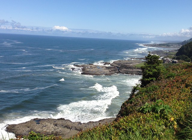
Oregon Coast from Cape Perpetua
A recent trip to meet up with old friends from graduate school gave us an opportunity to reacquaint ourselves with them and with the Central Oregon Coast as it had been many years ago when we interned in Portland. The coast line and beaches have changed little but the growth of previously small burgs is unavoidable. Being there in mid May afforded us minimal traffic but also iffy weather. As it worked out, it was fine. It rained on the afternoon we arrived and when we left five days later. Intermittent sun brought out the best the coast has to offer and contributed to the wonderful visit with old friends.
The Beach
The beaches themselves are endlessly fascinating, especially if you look beyond the sand. Our particular stretch of beach went on for seven continuous miles from Yachats (yah – hots) to Depot Bay. These beaches were immaculately clean as we found only a single piece of plastic over the four days we walked the beach. It was however naturally littered with clam shells and crab carapaces as it was molting season.

Storm Off shore

Sunset over Manzanita

Path to the beach

The Beach house

A molted hermit crab carapace

Tide swirls

Rock races on the beach
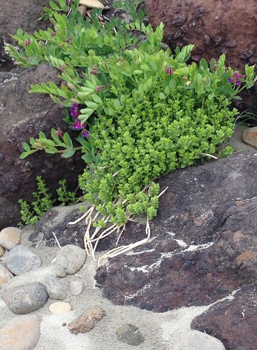
Sedum on the rocks

Flowers in the sand dune

Colorful beach erosion
The Coast sights: Beyond the Beach
As intriguing as is the beach itself, there is much more to see and do on the coast. About 30 miles north of Yachats on Highway 101 is the city of Newport situated around Yacquina harbor and is home to the OSU Hatfeild Marine Science Center, the Oregon Coast Aquarium, and recently, a local NOAA Operations Center .
A trip to Newport requires at least a visit to the Oregon Coast Aquarium. This is a wonderful aquarium with numerous exhibits. The Jellyfish displays are wonderful. Also, don’t miss the shark and other large fish that swim overhead, around, and under your feet in the “passages of the Deep.”

Moon Jellyfish (Aurelia aurita)

Tuft Puffin (Fratercula cirrhata)

Sea Otter (Enhydra Lutris)
As long as one is in Newport, it only makes sense visit the World famous Mo’s Restaurant for its famous Clam Chowder
Heceta Head Light house and trail.
Heading south from our base in Yachats, we find Heceta Head which is a promontory with a well known lighthouse above where Cape Creek runs into the ocean. The Bridge over the Creek (below) is National on the Register of Historic Places for its design resembling the Roman Aqueducts.
Hecta head was named for the Basque navigator Bruno de Heceta sailing for the Spanish who explored and surveyed this coast in 1775.
The half mile walk to the lighthouse is well worth the trip, both for visiting the Lighthouse as well as for the surrounding views. Volunteers provide assistance and natural history from several spotting scopes through which you can view the nesting Western Gulls and various Cormorants on the rocks below.

Roots along the trail

Sea stacks

Cape Creek Bridge

Heceta Head Lighthouse
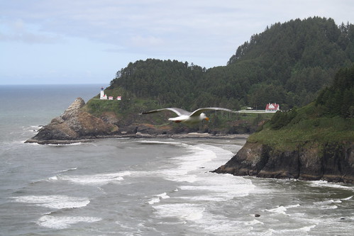
Gull’s eye view of Heceta Head

Nesting Gulls and Cormorants
The Devils:
Whoever named many of the natural sites must have had some issues with the devil. Along this stretch one can visit the Devil’s Punchbowl, Devil Lake, and as seen below, Devil’s Elbow Bay and Devil’s Churn. During storms and high tides, Devil’s Churn really does churn the surf.

Devil’s Churn

Devil’s Elbow Bay
Cape Perpetua Scenic Area visitor’s center with a US Forest Service outlook from which one can watch the Gray Whales in May migrating to Alaska as well as view their current flora exhibits from the area.

View from Cape Perpetua trail
Heading North
We leave Yachats on the Central Coast and head north along Highway 101 to Lincoln City and west over the coastal range to Forest Grove on the edge of the fertile Willamette Valley, home of the Oregon Wine Country. This Valley now produces some of the country’s best pinot noirs and various white wines that thrive in the moderate temperatures and silty soil long ago deposited by ancient glacial age floods. Below is just one of many wonderful wineries set in bucolic settings.

Elk Cove Vineyard near Gaston in the Willamette Valley
One other site in the Forest Grave area that is of interest but does not does not get as much as press as its wineries, is Sake One, the first Sake brewery in the States.
Heading northwest from the Willamette Valley and back on Highway 101, we arrive in Seaside, a favorite beach resort area referred to as the end of the Lewis and Clark Trail. Although the Corps of Discovery initially viewed the Pacific Ocean in Washington State from Cape Disappointment in 1805, they built a small fort named “Fort Clatsop” where they wintered just south of Astoria on the Oregon side of the Columbia before heading east again in the Spring.

Lewis and Clark’s end of the trail
It was very slow going for Lewis and Clark but also for us at times as this is “Oregon Logging Country.”

A common sight along the Oregon Coast, it does not pay to get into a hurry here. Note the double line and they are bigger than you.
Continuing north on highway 101, we came to the end of the Oregon Coast Scenic Drive and arrive at the famous Astoria Megler Bridge that spans the mouth of the mighty Columbia River. This bridge connects Washington State and Oregon and is one of the longest bridges in the US at 4.1 miles.

Astoria Megler Bridge across the Columbia River
And so ends our little sojourn to the Oregon Coast and highway 101.
As we headed back up to our home in Northwest Washington State we found just how tenuous these steel girded monsters are. Our route home “used” to cross the 1-5 bridge over the Skagit River near Mt. Vernon WA as seen below. The bridge collapsed just before our return home, after an oversized cargo truck hit one of the steel girders.

Collapsed bridge over Skagit River
A bit of detour around the bridge brought us to some roads that we had not seen before. It also and gave us the occasion to travel one of the most scenic byways in the state and arguably, the whole country: Chuckanut Drive. After traveling the scenic Oregon highway 101, we were “forced” to end our trip by viewing again our own local beauty, just a few miles from home.

Samish Bay and Samish Island, with the Olympic Mountains in the background
19 comments